Kargil
Kargil
Kargil, at 2,700 m elevation on the Leh-Srinagar highway, is the historic and cultural crossroads of western Ladakh. Marked by the 1999 conflict, it opens onto the Suru Valley and the Nun-Kun peaks.
Kargil is a mountain town in Ladakh, nestled in the Suru Valley at approximately 2,700 meters elevation. Ladakh's second-largest city after Leh, it occupies a strategic position on the Leh-Srinagar highway. A historic crossroads between Central Asia, Tibet, and Kashmir, it remains marked by the 1999 Indo-Pakistani war. Its predominantly Shia Muslim population gives it a distinct cultural identity in the region.
Quick Practical Information
- Elevation: approximately 2,700 m — allow time for acclimatization.
- Access: on NH1 (Leh-Srinagar national highway); travel by bus or taxi from Leh (approximately 200 km) or Srinagar (approximately 200 km).
- Road opening season: NH1 is generally closed in winter (November to April) depending on snow conditions.
- Dress code: modest clothing recommended, especially in mosques and religious spaces.
- Permits: no special permits required for Kargil town itself; some nearby border zones require an Inner Line Permit.
What to See
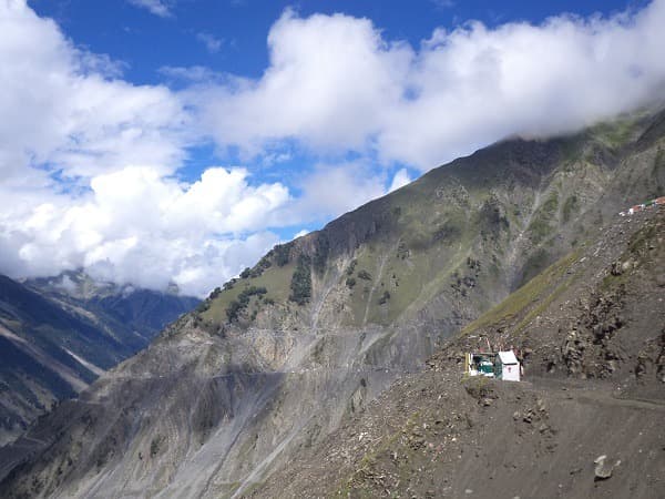
Kargil's central bazaar concentrates most commercial activity: spices, textiles, local products. Shia mosques, many adorned with colorful ceramic tiles, dot the town. The surroundings offer landscapes of narrow valleys, glacial rivers, and peaks exceeding 5,000 m. Suru Valley, extending to the south, provides access to the Nun-Kun glaciers.
History and Context
For centuries, Kargil was a commercial hub on caravan routes linking Leh to Srinagar and Kashmir. The town was integrated into Ladakh under Dogra rule in the 19th century, then attached to India following the 1947 partition. In 1999, the surrounding heights witnessed the Kargil conflict, which pitted the Indian Army against Pakistani infiltrators on the district's ridges. This conflict remains deeply embedded in local and national memory.
Highlights of a Visit
Kargil War Memorial
Built to honor Indian soldiers who fell in 1999, this memorial traces the conflict's progression through panels, displayed military equipment, and memorial stones. It stands as a place of reflection visited by many Indians.
Suru Valley
South of Kargil, the Suru Valley unfolds alpine meadows, stone villages, and views of the Nun (7,135 m) and Kun (7,077 m) peaks. It is one of the few Ladakh valleys that remain verdant during summer.
Mulbekh and Its Maitreya
About thirty kilometers east on the Leh road, the village of Mulbekh houses a Maitreya (Buddha of the Future) carved directly into the rock, dating from approximately the 8th century. This relief is one of the oldest Buddhist testimonies in western Ladakh.
Bazaar and Local Gastronomy
Kargil's bazaar offers local specialties influenced by Kashmiri and Ladakhi cuisine: salted butter tea, local bread, lamb-based dishes. Modest eateries in the center also serve common North Indian fare.
Etiquette and Visiting Rules
- Remove shoes before entering mosques.
- Women should cover their heads inside places of worship.
- Ask permission before photographing people or the interiors of mosques.
- Avoid visits during Friday prayer times.
Photography Tips
Morning light is ideal for photographing surrounding mountains from the town's heights. The bazaar comes alive mid-morning — a good time for street scenes. Views of snow-capped peaks are clearest early in the day, before heat haze settles in.
Location and Access
Kargil lies midway between Leh and Srinagar on NH1. The town is accessible by state bus or shared taxi from both cities. The nearest airport is Leh. In summer, the road is passable by car; in winter, it is often closed by snow. No rail access exists in the region.
Nearby Attractions
- Mulbekh — village to the east housing an 8th-century rock-carved Maitreya, an inevitable stop on the Leh route.
- Suru Valley — alpine landscapes and views of the Nun-Kun peaks, ideal for summer trekking.
- Rangdum — isolated monastery at the heart of Suru Valley, in a high-altitude setting.
- Leh — capital of Ladakh, approximately 200 km to the east, with its monasteries and royal palace.
Frequently asked questions
June to September, when NH1 is open and temperatures are mild. Outside this window, the road may be closed by snow and conditions become challenging.
Kargil town itself does not require a special permit. Some areas near the border or remote valleys may require an Inner Line Permit, depending on your itinerary.
By state bus or shared taxi on NH1. The journey typically takes a full day depending on road conditions and stops. The road crosses high passes, including Fotu La pass.
Yes, the population is predominantly Shia Muslim, which distinguishes Kargil from the rest of Ladakh, which is predominantly Buddhist. This identity is reflected in religious architecture and local cultural practices.
Yes, Suru Valley can be easily explored as an excursion from Kargil. Plan at least one additional day to reach Rangdum and enjoy high-altitude landscapes.
At approximately 2,700 m, Kargil is lower than Leh (3,500 m). Mountain sickness symptoms remain possible. Allow a rest day upon arrival and stay properly hydrated.
Photos
Want to discover this destination?
Our local advisors design your tailor-made trip.